View all Waratah Rivulet photos
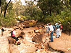
The images below show the shocking damage caused by longwall coal mining to the Waratah Rivulet, which flows into Woronora Dam.
Longwalls have run parallel to and directly under this once pristine waterway in the Woronora Catchment Special Area.
You risk an $11,000 fine if you set foot in the Catchment without permission, yet coal companies can cause irreparable damage like this and get away with it.
Also see When The River Runs Dry multimedia presentation. It was prepared by the Total Environment Centre and shows graphic images and details of the Longwall Mining effect on the Waratah Rivulet. (Sydney Morning Herald, 5th November 2007).
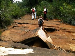
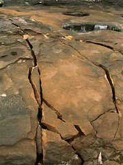 Severe cracking of rockbar |
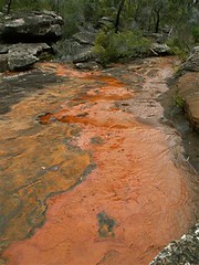 Iron oxide staining caused by iron that is normally trapped in the sandstone beneath the surface being released after cracking |
 This once beautiful waterfall is now dry and broken |
 What were once deeper sections of the rivulet are now completely dry |
 This was once a deep, crystal-clear pool. The little water that remains is polluted by iron oxide |
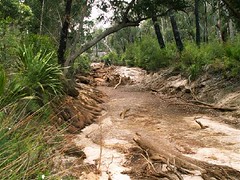 This once long, deep pool has drained like a bathtub and is now bone dry |
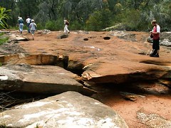
 A classic example of upsidence, where the stresses of the rock strata beneath, shattering and falling have caused the riverbed to bulge up |
 Looking back along the 2km stretch of dry riverbed |
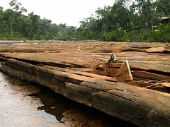 Sandstone strata opened up by subsidence |
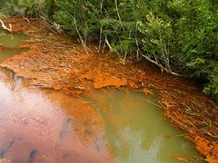 Iron oxide forms into floating mats which cling to vegetation |
Waratah Rivulet is a third order stream that is located just to the west of Helensburgh and feeds into the Woronora Dam from the south. Along with its tributaries, it makes up about 29% of the Dam catchment. The Dam provides both the Sutherland Shire and Helensburgh with drinking water. The Rivulet is within the Sydney Catchment Authority managed Woronora Special Area there is no public access without the permission of the SCA. Trespassers are liable to an $11,000 fine.
Longwall Mining under Waratah Rivulet
Metropolitan Colliery operates under the Woronora Special Area. Excel Coal operated it until October 2006 when Peabody Energy, the world’s largest coal mining corporation, purchased it. The method of coal extraction is longwall mining. Recent underground operations have taken place and still are taking place directly below the Waratah Rivulet and its catchment area.
In 2005 the NSW Scientific Committee declared longwall mining to be a key threatening process. The Waratah Rivulet was listed in the declaration along with several other rivers and creeks as being damaged by mining. No threat abatement plan was ever completed.
In September 2006, conservation groups were informed that serious damage to the Waratah Rivulet had taken place. Photographs were provided and an inspection was organised through the SCA to take place on the 24th of November. On November 23rd, the Total Environment Centre met with Peabody Energy at the mining company’s request. They had heard of our forthcoming inspection and wanted to tell us about their operation and future mining plans. Through a PowerPoint presentation they told us we would be shocked by what we would see and that water had drained from the Rivulet but was
reappearing further downstream closer to the dam.
The inspection took place on the 24th of November and was attended by officers from the SCA and DEC, the Total Environment Centre, Colong Foundation, Rivers SOS and two independent experts on upland swamps and sandstone geology. We walked the length of the Rivulet that flows over the longwall panels. Although, similar waterways in the area are flowing healthily, the riverbed was completely dry for much of its length. It had suffered some of the worst cracking we had ever seen as a result of longwall mining. The SCA officers indicated that at one series of pools, water levels had dropped about 3m. We
were also told there is anecdotal evidence suggesting the Rivulet has ceased to pass over places never previously known to have stopped flowing.
It appeared that the whole watercourse had tilted to the east as a result of the subsidence and upsidence. Rock ledges that were once flat now sloped. Iron oxide pollution stains were also present. The SCA also told us that they did not know whether water flows were returning further downstream. There was also evidence of failed attempts at remediation with a distinctly different coloured sand having washed out of cracks and now sitting on the dry river bed or in pools.
Also undermined was Flat Rock Swamp at the southernmost extremity of the longwall panels. It is believed to be the main source of water recharge for the Waratah Rivulet. It is highly likely that the swamp has also been damaged and is sitting on a tilt.
The longwall panels that have damaged the river are LW 8-13. These pre-dated the new approvals process that came into force in 2004. A Subsidence Management Plan for LW 14-17 was recently approved by the DPI and LW 14 is currently being mined. The SMP states that land above LW 8-13 had subsided about 1.3m on average and that there has been no significant impact upon net flow or water quality.
TEC has applied under FOI legislation to the SCA for documents that refer to the damage to the Waratah Rivulet.
During the meeting with Peabody on 23rd November, the company stated its intentions sometime in 2007 to submit a 3A application under the EP&A Act 1974 to mine a further 27 longwall panels that will run under the Rivulet and finish under the Woronora Dam storage area.
This is very alarming given the damage that has already occurred to a catchment that provides the Sutherland Shire & Helensburgh with 29% of their drinking water. The dry bed of Waratah Rivulet above the mining area and the stain of iron oxide pollution may be seen clearly through Google Earth.
The Bigger Picture
In 2005 Rivers SOS, a coalition of 30 groups, formed with the aim of campaigning for the NSW Government to mandate a safety zone of at least 1km around rivers and creeks threatened by mining in NSW.
The peak environment groups of NSW endorse this position and it forms part of their election policy document.
Longwall Mining under or close to Rivers and Streams:
Seven major rivers and numerous creeks in NSW have been permanently damaged by mining operations which have been allowed to go too close to, or under, riverbeds. Some rivers are used as channels for saline and acid wastewater pumped out from mines. Many more are under threat. The Minister for Primary Industries, Ian Macdonald, is continuing to approve operations with the Department of Planning and DEC also involved in the process, as are a range of agencies (EPA, Fisheries, DIPNR, SCA, etc.) on an Interagency Review Committee. This group gives recommendations concerning underground mine plans to Ian Macdonald, but has no further say in his final decision. A document recently obtained under FOI by Rivers SOS shows that an independent consultant to the Interagency Committee recommended that mining come no closer than 350m to the Cataract River, yet the Minister approved mining to come within 60m.
The damage involves multiple cracking of river bedrock, ranging from hairline cracks to cracks up to several centimetres wide, causing water loss and pollution as ecotoxic chemicals are leached from the fractured rocks. Aquifers may often be breached.
Satisfactory remediation is not possible. In addition, rockfalls along mined river gorges are frequent.
The high price of coal and the royalties gained from expanding mines are making it all too tempting for the Government to compromise the integrity of our water catchments and sacrifice natural heritage.
Longwall Mining in the Catchments
Longwall coal mining is taking place across the catchment areas south of Sydney and is also proposed in the Wyong catchment. Of particular concern is BHP-B’s huge Dendrobium mine which is undermining the Avon and Cordeaux catchments, part of Sydney’s water supply.
A story in the Sydney Morning Herald in January 2005 stated that the SCA were developing a policy for longwall coal mining within the catchments that would be ready by the middle of that year. This policy is yet to materialise.
The SMP approvals process invariably promises remediation and further monitoring. But damage to rivers continues and applications to mine are approved with little or no significant conditions placed upon the licence. Remediation involves grouting some cracks but cannot cover all of the cracks, many of which go undetected, in areas where the riverbed is sandy for example.
Sometimes the grout simply washes out of the crack, as is the case in the Waratah Rivulet.
The SCA was established as a result of the 1998 Sydney water crisis. Justice Peter McClellan, who led the subsequent inquiry, determined that a separate catchment management authority with teeth should be created because, as he said “someone should
wake up in the morning owning the issue” of adequate management.
An audit of the SCA and the catchments in 1999 found multiple problems including understaffing, the need to interact with so many State agencies, and enormous pressure from developers. Developers in the catchments include mining companies. In spite of government policies such as SEPP 58, stating that development in catchments should have only a “neutral or beneficial effect” on water quality, longwall coal mining in the
catchments have been, and are being, approved by the NSW government. Overidden by the Mining Act 1992, the SCA appears powerless to halt the damage to Sydney’s water supply.
