View all Upper Cataract River photos
The source of the Cataract River is in the Illawarra escarpment near Wollongong.
From here it flows west into the huge Cataract Dam, the northernmost of the four large storage dams in the region, which were Sydney’s only water supply until Warragamba Dam opened in the 1960s.
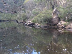
The Upper Cataract River consists of a stretch of approximately 8 km, flowing from the dam through pristine gorges in the highly protected catchment area, into a smaller dam called Broughtons Pass Weir.
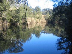
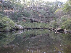
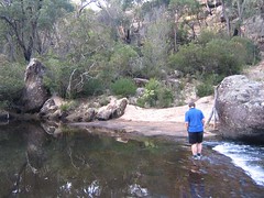
The photos below show the Upper Cataract before mining:
Below this weir is the Lower Cataract River: the stretch of the Cataract flowing into the Nepean River at Douglas Park, wrecked by longwall mining in the 1990s.
The Appin Falls are halfway along the bends of the Upper Cataract River, but this beauty spot is not open to the public. Anyone trespassing in the Sydney Catchment Authority’s Special Areas can be fined up to $11,000. These areas are fenced and all gates are locked.
At Broughtons Pass Weir, the small but vital dam crossed by Appin Road, the Cataract River’s water mixes with water pumped through the Nepean Tunnel from the Nepean, Avon and Cordeaux Dams to the south. This mix represents around 20% of Sydney’s water supply. Warragamba now supplies around 80%, but because the four older dams are nearer to the coast than Warragamba, they are fed with more coastal rain and in drought their levels have been slower to drop. This water from the south is indispensable to Sydney for another reason: if Warragamba is badly contaminated, for instance by toxic algal growths, this water provides an alternative source.
Most of this water then flows north from Broughtons Pass Weir along the Upper Canal, a heritage-listed structure and a gravity-fed engineering feat, carrying water all the way to Prospect Reservoir in western Sydney.
Some water is diverted from Broughtons Pass Weir to the nearby Macarthur Water Filtration Plant, supplying local towns and villages.
The Upper Cataract River is therefore a vital component of Sydney’s water supply, contributing an average of 7% of the input from the south.
It is also home to a colony of Macquarie Perch, a native fish species listed as endangered by both Federal and State Governments. Three threatened fauna species have been found near this river: the Red-crowned Toadlet, the Spotted Quail-thrush and the Painted Honeyeater. Eighteen threatened flora species have also been listed in this riparian zone.
The geological structure of the Upper Cataract is of course identical to the Hawkesbury sandstone of the Lower Cataract, and therefore prone to cracking and fracturing if mines are allowed to go too close to the river bed.
Rivers SOS protested against BHP Billiton’s plan with a submission to the NSW Government in September 2005.
[Rivers SOS submission – a 62KB PDF.]
[GREAT submission – a 33KB PDF.]
BHP’s plan placed three longwall mines only 50 metres from the cliffs of the Upper Cataract River, at Jordans Pass near Broughtons Pass Weir.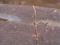
The 70m high cliffs descend vertically into the river at this point.
We said that cracking and pollution of the river was inevitable at this distance. The company’s own consultants said so too.
 The longwall panels were also too wide at 260 m.
BHP Billiton acknowledged that these wider panels cause more damage but say that narrower panels would not be economical.
 The Sydney Catchment Authority were not happy and employed an expert to give an independent opinion on a safe offset distance for mining near the river.
The opinion, relayed to the Government and its agencies who were considering the plan in detail, was that the safety zone needed to be 350m, certainly not less than 100m.
Minister Ian Macdonald went ahead and approved the mine plans in the face of all this community and expert advice.
This was in spite of the mines being in a supposedly highly protected catchment area, in an era of probable increase in drought and water shortages.
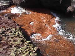
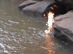
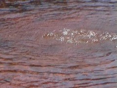
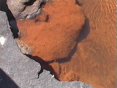
The results are as predicted.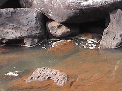
The mining has, by late 2007, left behind the predicted legacy of a cracked and fractured river bed – no doubt occasioning water loss – numerous bubbling methane gas vents which sustain a flame, iron oxides and other toxic chemicals leaching from the fractured rock, and rock-falls in the nearby cliffs.
 We cannot tell you whether the Macquarie Perch colony has survived this contamination of its habitat.

When are we going to learn that we have to strike a balance between business and development and sensible ecological protection. Don’t ruin this sensitive river. Australia is already leading the world in species extinction in the last 200 years. BHP Billington has other projects that they can work on to earn them a profit. Leave this area for our fauna and flora’s diversity’s sake.